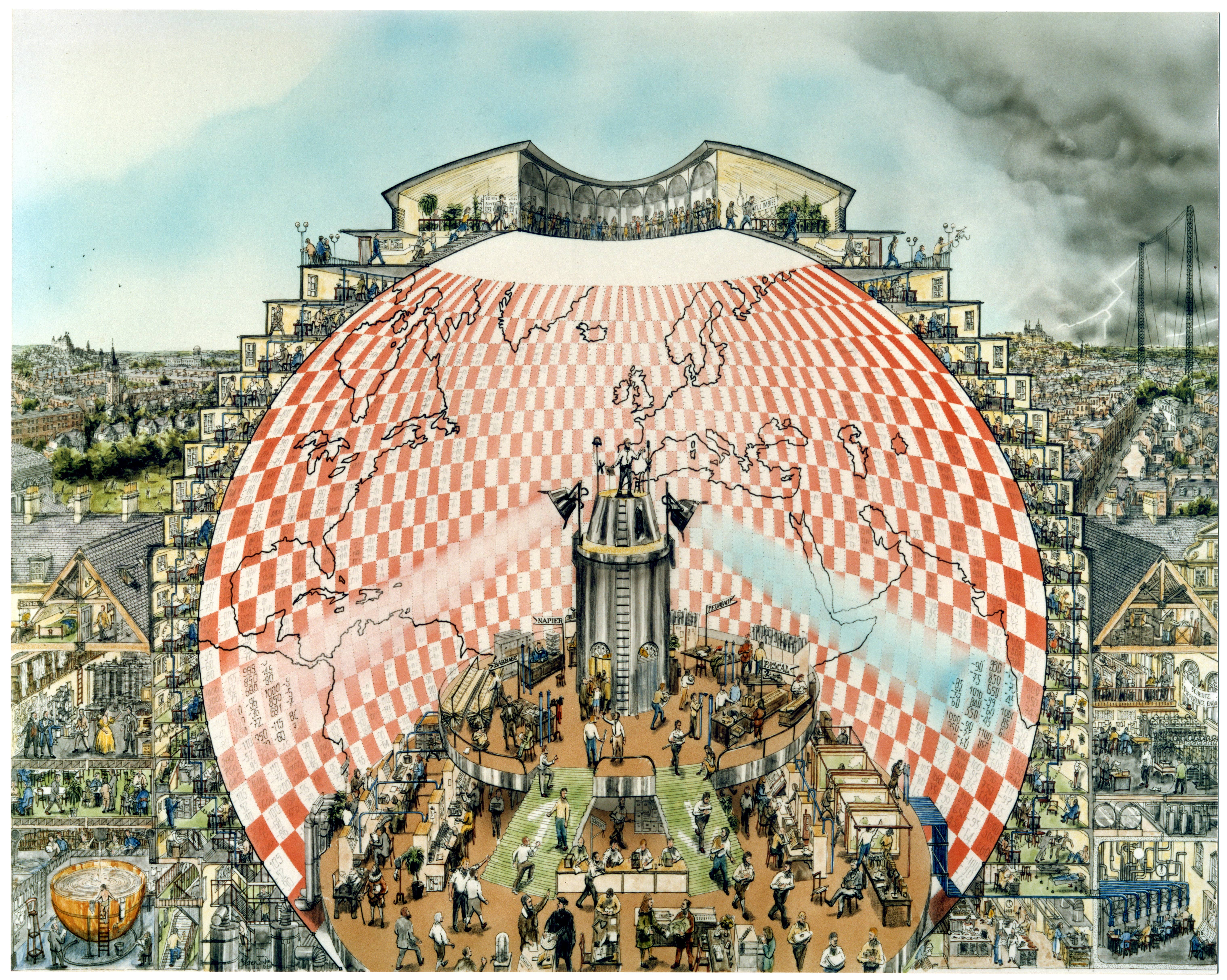
Resources
The Use of Satellite Information in Nowcasting and Short-range NWP
Findings and Recommendations from a Panel Discussion
EUMETSAT Satellite Conference, 21-25 September 2015, Toulouse
J. Schmetz, J. Onvlee, S. Benjamin, M. Kazumori, J.-F. Mahfouf, F. Rabier and R. Saunders
At the EUMETSAT Satellite Conference held in Toulouse from 21 – 25 September 2015, Jeanette Onvlee (KNMI) and Johannes Schmetz (EUMETSAT) convened a session on ‘Advances in Utilisation of Satellite Data for Nowcasting and Limited Area Modelling’. This session was concluded with a panel discussion entitled ‘Use of Satellite Information in Nowcasting and Short-range Numerical Weather Prediction (SRNWP)’. The panel was moderated by Florence Rabier, ECMWF, panel members included Stan Benjamin (NOAA), Masahiro Kazumori (JMA), Jean-Francois Mahfouf (Meteo France), Jeanette Onvlee (KNMI), Roger Saunders (UK Met Office). After a scene setting introduction by panel members a very stimulating discussion evolved with the audience of about 100 scientists. The purpose of this note is to record the salient points of this panel discussion for the benefit of the continued progress toward the best utilisation of satellite data for Nowcasting and Short-range Numerical Weather Prediction (NWP). The findings and recommendations are organised according to the two topics i) Salient points on numerical model developments and ii) Salient Points on Utilisation of Satellite Data in short-range NWP. In the following the terms mesoscale and short-range NWP are used as synonyms.
Salient Points on Numerical Model Development:
- For convective scale models upgrading the spatial resolution is required and already emerging with horizontal resolutions of the order of 1km or better and vertical resolutions that will capture inversions and boundary layer structure. Thus the models will evolve to a spatial grid spacing generally better than most satellite data.
- More frequent updating (from 10 minutes to 1 hour) and a very short latency of observations is required for assimilation into models moving into the current nowcasting range. Models are beginning to show good accuracy on the mesoscale for timescales down to the 1.5 – 2h range thereby improving over current nowcasting.
- The accurate representation of the lower part of atmosphere and the boundary layer, with emphasis on humidity structures in all phases and their variability in space and time is crucial for forecasting high impact weather phenomena. Model formulations for improved shallow convection and turbulence need to be introduced, which will also benefit from more diverse remote-sensing observations.
- There is a strong dependence of mesoscale forecasts on the boundary conditions used from global or large scale NWP models. Thus, SRNWP progress remains strongly linked to the large-scale model developments.
- The trend is for models to become more comprehensive ‘earth system models’ thus requiring, in addition to the meteorological information, also surface properties (moisture, vegetation, snow, sea ice, etc.) and atmospheric composition (aerosol, trace gases) as well as dynamic land-air coupling.
- Mesoscale model data assimilation is evolving using ensembles to better represent the background error statistics especially for cloud and precipitation variables. Both variational and ensemble assimilation approaches are under development for mesoscale models.
- Developments toward mesoscale ensemble prediction with improved uncertainty estimates is underway and necessary to be able to capture the limited predictability on small scales.
- Further improvements in model physics are needed to capture more realistic convection (including cloud processes) and turbulence at very high resolution. Case studies using satellite data will help to understand and validate model physics.
- Fine-scale models need to assimilate as many high-resolution observations as possible but at the same time avoid poor observations from entering the assimilation. Therefore, observations need to be quality-controlled, and, when necessary, thinned in an intelligent way taking into account the error covariances. Continuous processing and quality control of observations for assimilation will also help forecasters to ascertain critical weather current conditions.
- In order to more directly compare model and observations, tools to simulate satellite observations from model output are very desirable for both forecasters and model developers.
Salient Points on Utilisation of Satellite Data in SRNWP:
- Measurements and assimilation are needed at high spatial (better than 10 km) and temporal resolution (from 1h down to the order of 10 minutes or better). Very stringent latency requirements exist (~ few minutes) to meet short assimilation cut-off times that should require local data processing. Although geostationary satellites are generally expected to have the largest influence, LEO satellites play a strong role at high latitudes, also because of their microwave measurements. It is noted that potential LEO constellations could significantly improve temporal resolution for various observation types. A useful future way would be to enhance the imaging frequency at higher latitudes with observations from a highly elliptical orbit.
- Observing systems should focus on the representation of the lower atmosphere (boundary layer/inversions) and surface conditions.
- Horizontal and vertical gradient information on humidity, temperature and winds in different layers are very important.
- Challenging parameters and of critical importance to the short-range fine scale models are: 4-d moisture and clouds, including macro-physics (e.g. cloud top height and coverage) and micro-physics (phase, ice/water content, droplet size distributions) and information on cloud-condensation nuclei. Also important are surface properties, supporting the estimation of surface energy, water and momentum fluxes.
- A potential innovation is the use of time sequences of satellite image data by alignment of model fields with observed fields through a combination of image morphing techniques (field alignment) and with three-dimensional variational assimilation. Such systems are being introduced/developed, e.g. in Europe, Canada, and the US.
- Development of new metrics are needed to measure impact of data in SRNWP, which in turn is a new basis for assessing model quality.
- Systematic model errors need to be evaluated and corrected to utilise satellite data in an optimum manner.
- Satellite data can be used for model validation including many aspects of a model. It is recalled that this is a topic where expertise and interests of the nowcasting, SRNWP and (regional) climate communities can be of mutual benefit.
- In order not to be overwhelmed by the huge increase in data volume of both models and observations, methods need to be developed to intelligently synthesize relevant information into data volumes tractable for users, for example through principal component analysis (PCA). Actions to pursue and organise this are urgent for the new generation of instruments.
- New satellite data and products should be given to users for assessment as quickly as possible. While this has been done already with the global NWP model communities for earlier satellite programs, the new generation satellite programmes require also the involvement of the SRNWP and nowcasting communities. It is planned to have a joint ‘Nowcasting and SRNWP Workshop’ in 2016/17 with the objective to align activities and to establish a common workplan.
Furthermore the discussion between panellists and audience also highlighted a few points that specifically address observations from Meteosat Third Generation (MTG). Some are worthwhile to be recorded as complementary guidance on the already established development of the MTG applications ground segment: a) vertically resolved gradient information on water vapour and temperature should come with pertinent accuracies; b) concerning the use of lightning imager (LI) data, it was recommended to initially use LI observations as proxy for strong convection. In the longer term cloud electrification modules for SRNWP models will be developed as well as the corresponding forward operators for lightning observations; c) a further aspect noted during the discussion was the use of satellite data and SRNWP models for the planning and optimised operation of renewable energy farms (e.g. downwelling solar irradiance at the surface and accurate low-level wind fields).
